
Google Maps Origin Story (2003-2004)
Google Maps started humbly as a hand-sketched vision on a whiteboard in Sydney, Australia, and mushroomed into a key foundation of the world’s information infrastructure. It has more than a billion users, and millions of miles of streets are now captured on Google Maps across the world.
Motorists, city strollers, map worshippers and cartographers should thank Danish-born Jens and Lars Rasmussen, acknowledged by Google as the creative forerunners of Google Maps.

Jens and Lars Rasmussen (2010)
Source: smh.com.au
In 2003 they created a “tile server” -- a software application called Expedition that by 2004, under the corporate name of Where 2 Technologies, could be downloaded on desktops to deliver map tiles to clients. After Google acquired Where 2 in October 2004, Where 2 became accessible from the web, and both Rasmussens worked on the team that ultimately launched Google Maps.
While the brothers Rasmussen were toiling away on Google Maps, Google previously incorporated local listings into its search results in the form of a product called Google Local. Google Local displayed business listings and points of interest, but was not integrated with a Google-owned map yet, instead showing the listings on a map generated by MapQuest.

Google Local results (2004)
Source: googlepress.blogspot.com

Google Local results used a map from MapQuest (2004)
Source: googlesystem.blogspot.com
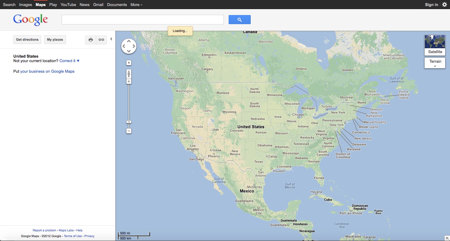
Google Maps Launched (2005)
Maps was released fully to the public on February 5, 2005 with a map of the United States. A major innovation from the initial launch
was the “draggable” map. This enabled users to click and drag the map display across the screen to view nearby areas,
without having to wait for those adjacent graphics to load onto the screen. This was a huge advance over the crowded field of
mapping competitors at the time, such as MapQuest.com, Mapblast.com, AAA.com (a paid service), and RandMcNally.com (also a paid service).
The first year the product was live, it underwent significant upgrades and new features were added constantly. Google Maps
was even renamed Google Local for a short time.

Google Maps Beta version (2004)
Source: connectme.typepad.com

Location point of interest balloon (2005)
Source: peterme.com

Map search results (2005)
Source: rosi-kessel.org

Map search results (2005)
Source: rosi-kessel.org

Driving directions (2005)
Source: wisc.edu

Maps renamed to Google Local, and satellite imagery (2005)
Source: astroarte.apaaweb.com

Location detail popup (2005)
Source: enews.org
Google Maps for Mobile (2005)
While the desktop version of Google Maps was gaining momentum, Google's vision for the product was much more ambitious. A Java version of Maps was being tested on mobile devices such as Blackberry, Palm, and Windows CE. It had the bare essentials for a mapping app, and lacked the elegance of the modern interface due to the lack of touchscreen capability on those older devices. Still, it was ahead of its time in mobile cartography and leveraged Google's large database of business listings.
Due to the richness of the product, Version Museum will have a separate in-depth history page for Google Maps for Mobile. Stay tuned.

Google Maps for Mobile Java app (2005)
Source: maps.googleblog.com
Public Transportation Integration (2005)
Google began working with public transit agencies to incorporate train and bus schedules into the product, expanding the overall utility of the service for general travel purposes. Coverage was extremely limited at first but grew dramatically over the years.

Transit Planner (2005)
Source: enews.org
Hurricane Katrina Imagery (2005)
Google realized early on how the Maps product could be used as a force for good. In the aftermath of Hurricane Katrina in 2005, which devastated New Orleans, Google had a special Katrina mode that showed images before and after the hurricane.

Hurricane Katrina imagery (2005)
Source: mediaspin.com
Google Earth Launched (2005)
A related product, google Earth, was released in June 2005. Based on technology from the acquisition of a company called Keyhole, Google Earth was a standalone free software download made available to all who wanted to use it. Over the years, Google Maps and Earth both used the same imagery, but were separate products. Maps was browser-based, while Earth was a separate app that ran on desktops, tablets, and phones. The line between the two was blurred somewhat due to the existence of an Earth browser plug-in. However, Google essentially merged the two by creating a fully native, first class browser-based version of Google Earth in 2017.

Early version of Google Earth (2006)
Source: systemsapproach.net
Moon Imagery (2005)
Google was a whimsical company in its early days, and Google Moon illustrates it perfectly. A few months after Maps launched, a few google engineers had the idea to use the platform to celebrate the 36th anniversary of the Apollo moon landing. As a result, Google Moon was launched on July 20, 2005, to display imagery of the surface of the moon. Apparently, this feat was pulled off in a week. And better yet, if you zoomed in all the way, the moon turned to swiss cheese, delighting children everywhere. The moon imagery is still alive today, and more has been added over time.

Google Moon Imagery (2005)
Source: astroarte.apaaweb.com

Google Moon Imagery Swiss Cheese (2005)
Source: quora.com
International Expansion (2006)
Google quickly expanded the country footprint for Maps in 2005 and 2006, launching maps for the UK, Japan, Canada, Germany, and Ireland. In 2007, it expanded to another 54 countries in Asia, Central America, and South America.

Driving directions in Germany (2006)
Source: adamhunter.me
Maps in Search Results (2006)
In late 2006, Google was confident enough in the Maps product to integrate it directly into the main Google.com search results.

Maps in search results (2006)
Source: mattcutts.com
Traffic Density (2006)
Traffic was displayed in select cities starting in 2006, with coverage expanded over time.

Maps has traffic (2006)
Source: blakeman.net
Street View (2007)

Sears Tower in Street View (2007)
Source: googleblog.com

LA Disney Concert Hall in Street View (2007)
Source: maps.googleblog.com
Easter Eggs (2007)
The playful side of Google Maps continued to be expressed in the form of clever Easter eggs. When searching for driving directions between locations in the United States and Europe, the service included a step to "swim across the Atlantic Ocean."

Easter egg to swim across Atlantic Ocean (2007)
Source: techpowerup.com
3D Buildings (2007)
Google Earth, the standalone desktop application, began incorporating 3D building designs into its imagery in 2006. Popular buildings in major cities were ported into the web-based Google Maps interface in 2007.

3D Buildings (2007)
Source: blogoscoped.com
Terrain View (2007)
Continuing the brisk pace of launches in the early years, the Google Maps team released a relief map feature. As explained on the Google Maps Blog, the terrain map layer showed elevation changes in different color shades.

Google Maps Terrain View (2007)
Source: Google Maps Blog
Walking Directions Launched (2008)
Google added walking as an option when getting directions. In 2010, biking directions were added.

Google Maps walking directions for NYC (2008)
Source: googlesystem.blogspot.com

Google Maps walking directions for SF (2008)
Source: googlesystem.blogspot.com
New Interface (2008-2009)
In late 2008, the user interface was modernized to give it a much cleaner look. The design of the pan and zoom controls were borrowed Google Earth, and Street View was made more accessible by giving "Peg Man" a front-row seat. Maps experimented with a full display of rendered vegetation colors in 2009 (as viewed in the second photo below), but ultimately it was shelved until its return in 2012.

Google Maps redesign showing US map (2009)
Source: tesl-ej.org

Google Maps redesign showing vegetation (2009)
Source: archive.fo
Embedded 45° Imagery (2009)
Sustaining the dizzying pace of feature releases, imagery taken at a 45-degree angle (also known as oblique imagery) was made available in 2009. Unlike satellite imagery, this footage was filmed and stitched together by low flying planes. It was only accessible for embedding via the Maps API at first -- meaning that users on the main Google Maps site couldn't use the feature. Third party travel sites were fans though, and embedded Google's oblique images to enhance their user experience. Below is travel site Orbitz.com's usage of the product.

Google Maps 45° imagery on travel site Orbitz.com (2009)
Source: tesl-ej.org
Google Map Maker Relaunch (2011)
With billions of points of interest on the planet, keeping a map up-to-date is a daunting task. Map Maker was originally launched in 2008 to enable crowd-sourced map editing of basic updates. Changes would be usually be reviewed by Google's internal team before going live for others. The 2011 Map Maker relaunch brought user editing powers to a whole new level. Users could edit practically anything on the map and its listings. The feature was live until 2017, when many of its features were baked directly into Google Maps itself.

Google Map Maker (2011)
Source: techerator.com

Google Map Maker with Earth plug-in (2011)
Source: thenextweb.com
Terrain and Vegetation Display (2012)
While Google's maps were getting more and more detail while zoomed-in, the zoomed-out maps that showed entire continents lacked detail. To rectify this, the maps where enhanced to show natural colors of vegetation and subtle terrain highlights.
Google Maps showing North America (2012)
Source: web.archive.org
Redesigned From The Ground Up (2013)
Google launched a completely revamped Maps site in 2013; it was a huge leap forward in style and functionality compared to the existing version.
Not only was the appearance striking, the map was personalized to the individual user and kept track of places the user searched for and visited.
The visual experience was enhanced by a powerful graphics platform called WebGL which allowed visual elements and Google Earth to be
embedded in a way not seen before.
The map itself was expanded and no longer confined to a portion of the browser window. In fact, the map footprint became the entire
viewing area of the browser, creating a stunning cartography immersion. When the top left search box was used, results expanded from it
showing all the needed details. And when viewing a wider area like a city, the "Explore" box popped open at the bottom, highlighting
popular points of interest.
And last, but certainly not least, if the user zoomed all the way out, all of Earth was shown from space as a globe. And the Sun was in the background too,
if it was angled properly. It
was so realistic that it had accurate weather patterns on the surface of our humble planet. Cloud cover and giant weather formations
were properly depicted! And not only that, where it was nighttime on Earth, the darkness was punctuated with lights from cities.
The attention to detail was amazing.

Google Maps overhaul showing entire world (2013)
Source: maps.googleblog.com

Google Maps redesigned place details (2013)
Source: maps.googleblog.com

New York City in redesigned Google Maps with Explore box (2013)
Source: maps.googleblog.com

Redesigned directions planner showing a flight (2013)
Source: theverge.com

New Street View experience with Explore box (2013)
Source: maps.googleblog.com

Earth from space with accurate cloud cover (2013)
Source: omgchrome.com
Pac Man April Fool's Game (2015)
Continuing Google's tradition of April Fool's features, Google Maps allowed users to play Pac Man inside whatever map view was currently live. This created a completely unique game board and upped the difficulty level. In 2017, Google launched a version of Ms. Pac Man inside the mobile maps app.

Pac Man inside Google Maps (2015)
Source: boingboing.net
Material Design (2015)
Google announced an entirely new look and feel for its web and app-based user interfaces in 2014 called Material Design. It took until mid-year 2015 to come to Google Maps, but it was a noticeable change, confined mostly to the left-hand info bar. Material Design would be front and center in almost everything Google touched from 2015 on. We're all about design here at Version Museum, so check out Google's in-depth site on the topic.

Google Maps Material Design UI (2015)
Source: 9to5google.com

Google Maps Material Design UI (2015)
Source: seroundtable.com
Sharper Satellite Imagery (2016)
With the help of the state of the art Landstat 8 imaging satellite, Google's imagery took a leap forward in sharpness and detail. It was a big improvement over Landstat 7, which was their primary source previously.

Landstat 7 imagery (top) versus Landstat 8 imagery (bottom) (2016)
Source: theverge.com
2010 vs 2016 Google Maps Comparison (2016)
Justin O’Beirne put together a fantastic in-depth look at the changes in Google Maps layers over time. The image below shows the change in map detail from 2010 to 2016 -- an overall decrease in label density. In fact, Mr. O'Beirne has a variety of fascinating deep dives into the user interface of Google Maps and how it compares to Apple's Maps.

Google Maps label density comparison, 2010 vs 2016 (2016)
Source: justinobeirne.com
New Iconography with Consistent Colors (2017)
As the footprint of Google's map listings grew, so did the complexity of displaying all those points of interest in a consistent way across all Google's properties. Google Maps, Google search, the Google Assistant, Google Earth, and other apps all adopted this consistent color scheme and icon set to bring order to the chaos.

Google's new icon color scheme (2017)
Source: blog.google

Google's new icons for points of interest (2017)
Source: blog.google
Google Maps Surface Becomes A Globe (2018)
As of 2013, users saw Earth as a globe from space when they zoomed all the way out. But the transition was somewhat startling and the map itself didn't function like a globe when panning; it used the mercator projection, which makes Earth appear flat. That all changed in 2018, when Maps did away with the mercator projection and the map itself became a globe. The curvature of the Earth was readily apparent, likely to the disappointment of those silly flat-Earthers.

Google Maps surface becomes a globe (2018)
Source: theverge.com
14th Anniversary of Google Maps (2019)

Google Maps view of Europe (2019)
Source: VersionMuseum.com

Google Maps satellite imagery view of South America (2019)
Source: VersionMuseum.com
Please help support our museum hosting costs by making a small donation -- buy us a coffee! Thank you so much!
Scroll up to the top.